[7.27] M7.0 지진은 유산 건물과 교회를 손상시킵니다
컨텐츠 정보
- 22,322 조회
본문
마닐라 – 수요일 아침 아브라 지방을 강타한 리히터 규모 7.0의 강진으로 루손 북부 일부 지역의 유적지들이 피해를 입었습니다.
소셜미디어에 유포된 영상에서 보듯, 일로코스 수르 반타이에서는 역사적인 반타이 종탑이 지진으로 무너질 뻔했습니다.
관광부에 따르면, 수세기 동안 이 교회 종탑은 스페인 식민지 기간 동안 두 지역 모두를 해적과 다른 적들로부터 보호하면서 마을과 인근 수도 비건의 망루 역할을 했습니다.
비건 시의 A Reyes St.에 있는 몇몇 오래된 건물들도 지진으로 피해를 입었습니다.
한편, 아브라의 타윰에 있는 산타 카탈리나 데 알레한드리아 교구 교회의 일부도 강한 지진으로 인해 손상되었습니다.
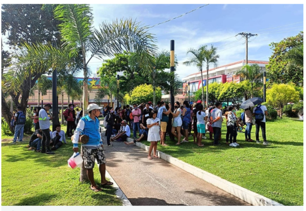
아브라의 뱅게드 지역 주민들도 지진이 발생하자 집이나 사무실 건물에서 떼를 지어 뛰쳐나왔습니다.
필리핀은 일본에서 동남아시아를 거쳐 태평양 분지를 가로질러 뻗어있는 강렬한 지진 활동의 호인 "불의 고리"에 위치해 있기 때문에 정기적으로 지진에 의해 흔들립니다.
수요일의 지진은 필리핀에서 몇 년 만에 가장 강한 지진이었습니다. 2013년 10월 필리핀 중부 보홀섬에서 규모 7.1의 지진이 발생해 200명 이상이 사망하고 산사태가 촉발됐습니다.
필리핀의 가톨릭 발상지에 있는 오래된 교회들이 심하게 훼손되었습니다. 거의 40만 명의 이재민이 발생했고 수만 채의 집들이 피해를 입었습니다.
이 강력한 지진은 섬의 풍경을 바꾸어 놓았고 "지반 파열"은 진원지 위에 암벽을 만들면서 3미터까지 확장 된 땅을 밀어올렸습니다.
1990년, 필리핀 북부에서 진도 7.8의 지진이 100킬로미터가 넘는 지반 파열을 일으켰습니다.
사망자는 1,200명이 넘을 것으로 추정되었고 마닐라의 건물들에 큰 피해를 입혔습니다.
이 나라의 화산 및 지진 연구소는 정기적으로 지진 훈련을 실시하며, 국가의 활성 단층선에서의 시나리오를 시뮬레이션합니다.
큰 지진이 일어나는 동안, 그 기관은 사람들이 높은 층에 서 있는 것이 힘들고, 나무가 강하게 흔들릴 수 있고, 무거운 물건과 가구가 넘어지고, 큰 교회 종이 울릴 수 있다고 말했습니다.
This is the Original Article from ABS-CBN NEWS
MANILA — A 7.0-magnitude earthquake that struck Abra province Wednesday morning inflicted damage on heritage sites in parts of northern Luzon.
In Bantay, Ilocos Sur, the historic Bantay Bell Tower almost collapsed in the quake as shown in videos circulated on social media.
The centuries-old church belfry previously served as a watchtower for the town and for the nearby capital city of Vigan during the Spanish colonial period, protecting both areas from pirates and other enemies, according to the Department of Tourism.
Several old structures in Gov. A Reyes St. in Vigan City also sustained damage in the quake.
Meanwhile, parts of Santa Catalina de Alejandria parish church in Tayum, Abra were also damaged in the strong tremor.
Residents in Bangued, Abra also rushed out of their homes and office buildings in droves when the quake occurred.
The Philippines is regularly rocked by quakes due to its location on the Pacific "Ring of Fire," an arc of intense seismic activity that stretches from Japan through Southeast Asia and across the Pacific basin.
Wednesday's quake was the strongest recorded in the Philippines in years. In October 2013, a magnitude 7.1 earthquake struck Bohol Island in the central Philippines, killing over 200 people and triggering landslides.
Old churches in the birthplace of Catholicism in the Philippines were badly damaged. Nearly 400,000 were displaced and tens of thousands of houses were damaged.
The powerful quake altered the island's landscape and a "ground rupture" pushed up a stretch of ground by up to three meters, creating a wall of rock above the epicenter.
In 1990, a magnitude 7.8 earthquake in the northern Philippines created a ground rupture stretching over a hundred kilometers.
Fatalities were estimated to reach over 1,200 and caused major damage to buildings in Manila.
The nation's volcanology and seismology institute regularly holds quake drills, simulating scenarios in the nation's active fault lines.
During major earthquakes, the agency said people would find it difficult to stand on upper floors, trees could shake strongly, heavy objects and furniture may topple and large church bells may ring.
관련자료
-
이전
-
다음


